HIST 100: Engineering The Past

  • Home
  • Syllabus
  • Schedule
  • Blog

Concept Map- Aztec Culture

February 27, 2016 by Jessica F. 1 Comment

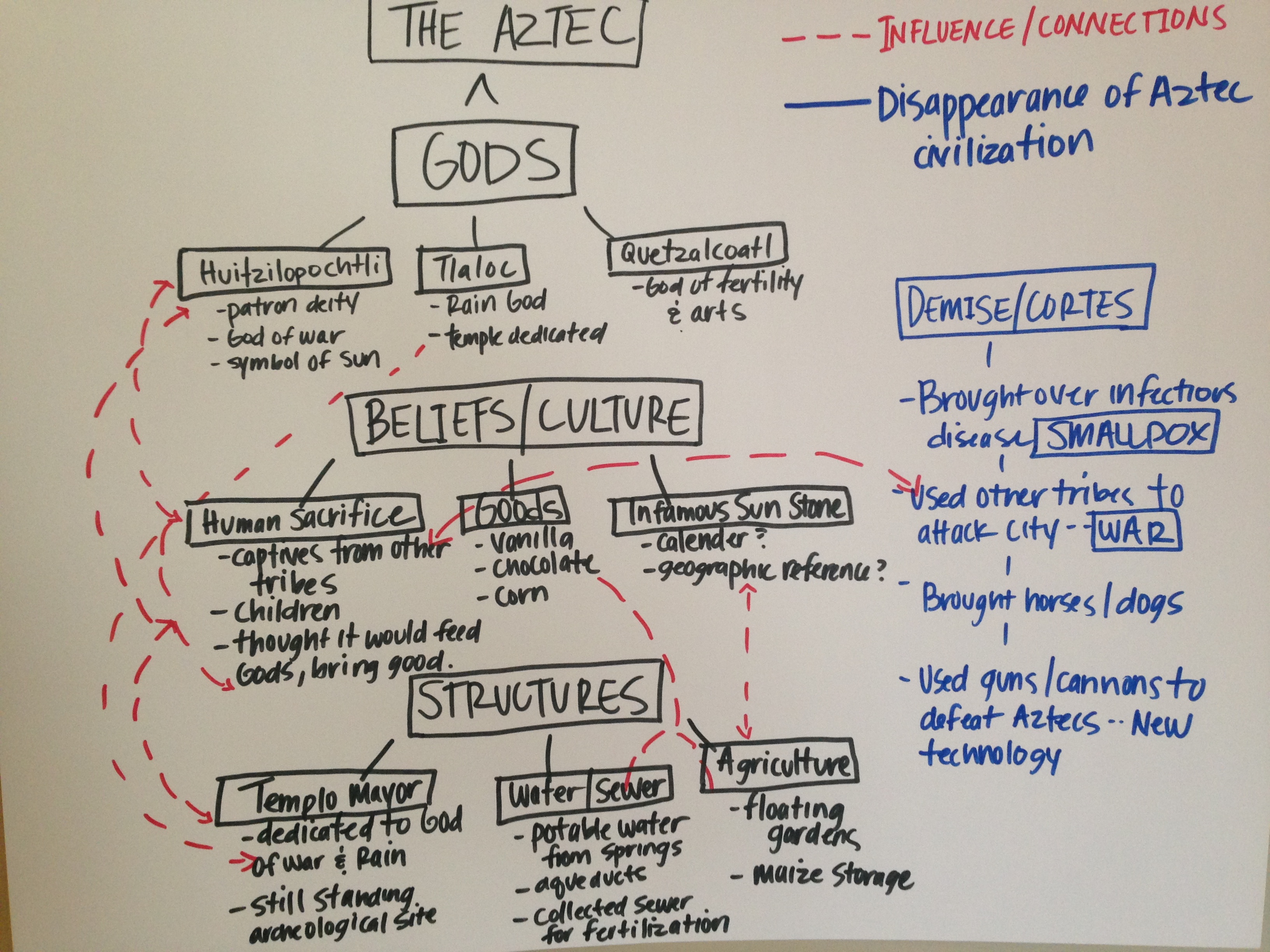
I chose to do my concept map on the Aztec culture/civilization because I am very interested in how they lived and what they believed in. I organized it based on what I found interesting and how those subjects related to each other. I chose to draw it out on a large piece of paper because I am a visual person and I don’t prefer to use technology.

As you can see I used red to connect themes and subjects that influence each other. For instance the Aztec’s believed in Gods so they built structures (temples) to honor them and then sacrificed humans at those structures to please their Gods. They might have believed that by sacrificing humans it would bring light, rain and fertility to their people. I was also interested that the Aztec’s were a “clean” civilization. They got their water from clean springs and disposed of their sewage in a modern way. They also reused their sewage as fertilizer for the floating gardens. Last but not least I was fascinated by how people think that the Aztec’s “disappeared”. But really their civilization was confronted by a Spanish Conquistador Cortes, who wanted to conquer their city. He found that surrounding tribes were enemies to the Aztecs and used them to wage war. Many Aztec’s perished because unknowingly the Spanish fleet brought over a deadly disease, smallpox. It wiped out at least half of the population because they had never been exposed to the disease, and therefore did not have immunity to it.

IMG_0320


Filed Under: 0.0 Concept Map Assignment, Group 1

Machu Picchu Concept Map

February 26, 2016 by kylemitsunaga Leave a Comment

Machu Picchu concept map


My concept map is over the Machu Picchu, I found it pretty amazing that the Incas were able to design a working city that is on a mountain. I tried to keep my map simple and easy to follow therefore I broke it down into the design. From there I divided it into the agriculture sector and the urban sector. In the urban sector there are three parts to it which are: Sacred District, Popular District, and the Royalty District. What is interesting about this is that in the sacred district they have all of the temples and places to worship for the Inca’s. This is an area that I feel like different people such as the Aztecs had their own version of temples or places of worship. I found it interesting seeing the difference and connecting how the Machu Picchu and other cultures incorporated their places of worship. The popular district is where the lower class or the common people lived. In the royalty district the priest and wealthy people lived, which as you could imagine the houses were a little bit bigger and nicer than the popular district. Switching gears and going into the agriculture sector this is where they grew food and crops. This area is divided into a lower and upper level. They had a well thought out irrigation system that worked. They also had a way to prevent erosion for when it rained and it did quite a bit in Peru where the Machu Picchu is. Basically the Incas had built a working city that is on top of a mountain with all the needs of life. They were very hard working people as we can see in the Machu Picchu. This place isn’t the only culture that has done something like this. Most cultures have their own towns and the ways of doing things. Machu Picchu just seem to interest me more since it is well thought out and built on a mountain.

Filed Under: 0.0 Concept Map Assignment, Group 1

4.1 Hagia Sophia

February 20, 2016 by petewcook 1 Comment

Hey y’all Pete here. The purpose of this post is to tell you a little about the architectural features of Hagia Sophia. These features were added onto the structure during it’s time as a Mosque from 1453-1935.

Prior to 1481 a small minaret was built above the stair tower on the southwest corner of the building. Later, another minaret at the northeast corner of the building was built by the succeeding sultan, Bayezid ll (1481-1512). After the Earthquake of 1509, one of the minarets collapsed and near the middle of the 16th century two diagonally opposite minarets were built at the east and west corners of the building in place of the old ones. The first minaret by the southwest corner was built from red brick while the other three were built from white limestone and sandstone. The two larger minarets were built by Sultan Selim ll and designed by Mimar Sinan, the famous Ottoman architect. During the 16th century, Sultan Suleiman the Magnificent returned to the structure with two massive candlesticks from his conquest of Hungary. They placed these on either side of the mihrab. In 1740 under Sultan Ahmed lll, a Sidirvan, fountain for ritual ablutions, was added to the structure. A new mihrab was also added at this time. During the Renovation of 1847 the minbar and mihrab were renovated and the two minarets were also set to equal heights.

Filed Under: 04.1 Hagia Sophia, Group 2

  • « Previous Page
  • 1
  • …
  • 47
  • 48
  • 49
  • 50
  • 51
  • …
  • 94
  • Next Page »

Students

Log in here.

Groups

Student Contributions

From the Professor

Copyright © 2025 · Minimum Pro Theme on Genesis Framework · WordPress · Log in